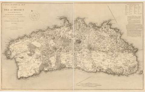
A Topographical map of the isle of Minorca


 Disponible Holdings
 Section: Maps, plans and nautical charts
Uniform title: MENORCA (Baleares). Mapas generales. 1:55.000 (1780)
Title: A Topographical map of the isle of Minorca / geometrically survey'd by the Royal Engineers while it remained in the possesion of the French during the last war, and digested by L.S. de la Rochette
Material or type of resouce Area: Escala [ca. 1:57000], 4 English Statute Miles [= 11,4 cm]
Publication: [Madrid ? : s.n., 18-- ?]
Physical description: 1 mapa ; 60x95,5 cm, pleg. en 60x47,3 cm
Notes: Escalas gráficas de Common French leagues [= 16,8 cm] y Common Spanish league [= 10,2 cm]. Coordenadas del Castillo de San Felipe referidas a un meridiano que no se especifica. Orientado con lis en cuadrante
Relieve representado por sombreado
Relación de las principales vías de comunicación indicadas por clave alfabética
Tabla de términos utilizados en español y su correspondiente en inglés
Indica carreteras y núcleos de población
Nota relativa a la toponimia y al desarrollo histórico de la isla
Reproducción en ozalid de la publicada en Londres por William Faden en 1780
Se dispone además del original con sig. SG+Ar.G bis-T.3-C.3-119
Materia / lugar / evento: Mapas generales
Defensa de costas
1780
Other authors: La Rochette, Louis Stanislas D'Arcy de
Faden, William, 1749-1836
UDC: 912(467.5 Menorca)'1780'
467.5 Menorca
Type of publication:
 Maps
Maps
Rights:
Préstamo:
Disponible
