A New Chart of the River Plate : compiled from the...


 Maps, plans and nautical charts
A New Chart of the River Plate : compiled from the Observations of Capn. Heywood (1821)
Maps, plans and nautical charts
A New Chart of the River Plate : compiled from the Observations of Capn. Heywood (1821)
 Disponible Holdings
 Section: Maps, plans and nautical charts
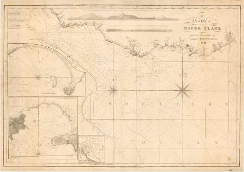
Uniform title: LA PLATA (Río). Cartas náuticas. 1:550000 (1821)
Title: A New Chart of the River Plate : compiled from the Observations of Capn. Heywood
Material or type of resouce Area: Escala [ca. 1:550000 ; proy. Mercator] (O 59°06'--O 54°06'/S 34°05'--S 36°45')
Publication: London : Robt. Blachford, Navigation Warehouse No.79 Leadenhall St., 1821
Physical description: 1 mapa : montado sobre tela ; 56 x 81 cm
Content type: Imagen cartográfica
Media type: computadora
Carrier type: recurso en línea
Notes: Comprende además el S. de Uruguay y el N.E. de Argentina
Escala hallada a partir de un grado de latitud [= 19'9 cm]. Coordenadas también referidas al meridiano de Cádiz (O 52°50'--O 47°50'). Red geográfica de 30' en 30'. Orientado con lis en dos rosas de vientos, en las que se indica el norte y grado de declinación magnética
Relieve por normales
Indica sondas batimétricas, veriles, fondeaderos, calidad del fondo; así como las líneas de derrotas seguidas por varios barcos
Nota relacionada con la naturaleza y carácter de las mareas
Tabla de signos para indicar los puntos en los que se han realizado observaciones astronómicas
El margen superior, recoge tres perspectivas de parte de la costa representada
Es una copia de la publicación realizada en 1812 por la Dirección de Hidrografía
Inserta : "The Harbour of Maldonado".- Escala [ca. 1:38000], 1 milla naútica [= 4'8 cm]; "The Harbour of Monte-Video".- Escala [ca.1 1:30000], 1 milla náutica [= 6'0 cm]; "Puerto de Buenos aires"._ Escala [ca. 1:48000], 1 milla náutica [= 3'8 cm]
Materia / lugar / evento: Cartas náuticas
Planos de población
Perspectivas de costas
Fondeaderos
1821
Uruguay
Buenos Aires
Montevideo (Uruguay)
Maldonado (Uruguay)
Other authors: Heywood, R.N
Blachford, Robert
UDC: (282.281.6 La Plata)
Type of publication:
Maps
Rights:
Préstamo:
Disponible
