A Military Sketch of the Country between Lisbon and...


 Maps, plans and nautical charts
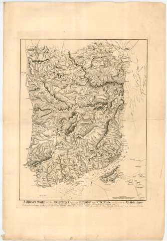
A Military Sketch of the Country between Lisbon and Vimiero occupied by the British Army : under the Command of... (January 15th. 1827.)
Maps, plans and nautical charts
A Military Sketch of the Country between Lisbon and Vimiero occupied by the British Army : under the Command of... (January 15th. 1827.)
 Disponible Holdings
 Section: Maps, plans and nautical charts
Uniform title: Portugal. Mapas generales. 1:100000 (1827)
Title: A Military Sketch of the Country between Lisbon and Vimiero occupied by the British Army : under the Command of Lieutenant General Viscount Wellington / M. Thomson sc. ...
Edición: 2nd ed., col. from the Trigonometrical Operations of M : Giera, & the Surveys of the Portuguese and French Engineers
Material or type of resouce Area: Escala [ca. 1:100000], 8 Britih Miles [= 13,3 cm]
Publication: [London ?] : Published with permission of the Quarter Master General by James Wyld, Geographer to His Majesty, 5 Charing Cross, January 15th. 1827.
Physical description: 1 mapa ; 64,3x48,3 cm en h. de 86,6x59 cm
Content type: Imagen cartográfica
Media type: computadora
Carrier type: recurso en línea
Notes: Orientado con flecha en cuadrante
Relieve representado por normales
Indica batimetría
Indica núcleos de población y caminos
Other authors: Thomson, M
Wyld, James, 1790-1836
UDC: 912(469)'1827'
(469 Lisboa)
(469 Vimiero)
Type of publication:
Maps
Rights:
Préstamo:
Disponible
