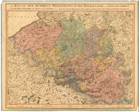
A Map of the Austrian possessions in the Netherlands or...


 Maps, plans and nautical charts
A Map of the Austrian possessions in the Netherlands or Low Countries : with the principalities of Liege and... (Jany. 1st 1789)
Maps, plans and nautical charts
A Map of the Austrian possessions in the Netherlands or Low Countries : with the principalities of Liege and... (Jany. 1st 1789)
 Disponible Holdings
 Section: Maps, plans and nautical charts
Uniform title: BELGICA. Mapas generales (1789). 1:460000
Title: A Map of the Austrian possessions in the Netherlands or Low Countries : with the principalities of Liege and Stavelo, reduced from the trigonometric survey / made by order H.R.H. the Prince Charles of Lorraine
Material or type of resouce Area: Escala [ca. 1:460000], 12 common French Leagues [= 11, 6 cm]
Publication: London : William Faden, Geographer to His Majesty, Jany. 1st 1789
Physical description: 1 mapa : col. ; 48x65,5 cm en h. de 56x70 cm
Content type: Imagen cartográfica
Media type: computadora
Carrier type: recurso en línea
Notes: Escalas gráficas de 10 leguas de Brabante [= 11,5 cm], 40 millas inglesas [= 12,3 cm] y 8 millas alemanas [= 11,4 cm]. Coordenadas referidas al meridiano de Londres (E2°25'-E7°05'/N51°40'-N49°30')
Relación de las diferentes provincias y los estados a los que pertenecen indicadas por clave numérica
Indica núcleos de población y masas forestales
Materia / lugar / evento: Mapas generales
Divisiones administrativas
1789
Other authors: Faden, William, 1749-1836
UDC: 912(493-2/-5)'1789'
493
Type of publication:
Maps
Rights:
Préstamo:
Disponible
