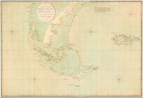
A Chart of the Southern Promontory of America


 Disponible Holdings
 Section: Maps, plans and nautical charts
Uniform title: AMERICA DEL SUR. S. Cartas náuticas. 1:1660000-1:3580000 (1797)
Title: A Chart of the Southern Promontory of America / drawn from the English & Spanish Surveys By A. Arrowsmith, Geographer Charles Street, Soho, London
Material or type of resouce Area: [Ca. 1:1660000-1:3580000] (O 80°39'-O 56°12'/ S 36°00'-S 57°28')
Publication: London : Published... by A. Arrowsmith, Charles Street, Soho, 1st. April 1797
Physical description: 1 carta náutica : col., montado sobre tela ; 63 x 93 cm
Content type: Imagen cartográfica
Media type: computadora
Carrier type: recurso en línea
Notes: Comprende las costas de Argentina desde el cabo San Antonio y la de Chile desde la isla Campana, con las Malvinas
Escala hallada a partir de 1° de latitud [= 6,7 cm] en el paralelo 57° S., [= 3,1 cm] en 38° S. Proyec. Mercator. Red geográfica de 1° en 1°. Cinco nudos de 32 vientos
Indicas sondas batimétricas, bajos, veriles y derrotas de viajes realizados por el Capitan Cook en 1774
Leyenda explicativa sobre la Patagonia en la parte superior
Coloreado en verde
Inserta: "Continuation of the Coast from Cape Blanco to the River Plate from an English MS"
Materia / lugar / evento: Cartas náuticas
Derroteros
Expediciones geográficas
Costas
Ríos
Islas
1797
Chile
Argentina
Malvinas (Islas)
América del Sur
Other authors: Arrowsmith, Aaron, 1750-1823
UDC: (8)
Type of publication:
 Maps
Maps
Rights:
Préstamo:
Disponible
