A Chart of The Indian Ocean : Improved from The Chart or...


 Maps, plans and nautical charts
A Chart of The Indian Ocean : Improved from The Chart or M D'Apres de Mannevillette with The Addition of a Part of... (1803)
Maps, plans and nautical charts
A Chart of The Indian Ocean : Improved from The Chart or M D'Apres de Mannevillette with The Addition of a Part of... (1803)
 Disponible Holdings
 Section: Maps, plans and nautical charts
Uniform title: INDICO (Océano). Cartas náuticas (1803). 1:3000000
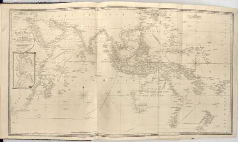
Title: A Chart of The Indian Ocean : Improved from The Chart or M D'Apres de Mannevillette with The Addition of a Part of The Pacif Ocean as well as of The Original Tracks of The Principal Discoverers or The Navigators to India and China and in which it has been attempted to give a Chronological Indication of The succesive Discoveries / By. L.S. De La Rochette
Material or type of resouce Area: Escala [Ca. 1:3.000.000] ; [proyec. Mercator]
Publication: London : Published by W. Faden Geographer to The King and to H.R.H The Principe of Wales, 1803
Physical description: 1 carta nautica ; 61x113 cm en h. de 66x119 cm, pleg en 48'5x65 cm
Content type: Imagen cartográfica
Media type: computadora
Carrier type: recurso en línea
Notes: Presenta además 2 mapas de 'North - East Monsoon' y 'South west Monsoon'
En : 'Charts Red Sea'
Escala grafica hallada a partir de un grado de latitud [= 3'5 cm]. Coordenadas referidas al meridiano de Londes (E15°50'-E190°25'/N35°10'-S45°25'). Red geografica de 5° en 5°. Orientado con lis en nudo de rumbos
Relieve representado por sondas batimetricas
Indica veriles, bajos y fondeaderos
En el margen inferior 'Approved by The Chart Comittee of The Admiralty'
En : Charts Red Sea
Materia / lugar / evento: Cartas náuticas
Derroteros
1803
Other authors: La Rochette, Louis Stanislas D'Arcy de
Faden, William, 1749-1836
UDC: 912:[551.46:527.6](267)'1803'
267
Type of publication:
Maps
Rights:
Préstamo:
Disponible
