Plan of the Island of Dominica : laid down by Actual...


 Maps, plans and nautical charts
Plan of the Island of Dominica : laid down by Actual Survey under the Direction of the Honorable The Commissioners... (Novr. 1st. 1776)
Maps, plans and nautical charts
Plan of the Island of Dominica : laid down by Actual Survey under the Direction of the Honorable The Commissioners... (Novr. 1st. 1776)
 Disponible Holdings
 Section: Maps, plans and nautical charts
Uniform title: Dominica. Mapas generales. 1776. 1:32.000
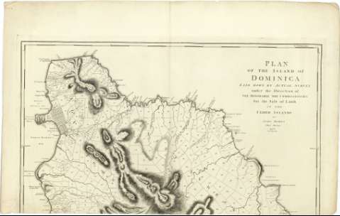
Title: Plan of the Island of Dominica : laid down by Actual Survey under the Direction of the Honorable The Commissioners for the Sale of Lands in the Ceded Islands / by John Byres Chief Surveyer ; J. Bayly Sculp. London
Material or type of resouce Area: Escala [ca. 1:32000]
Publication: London : Published by S. Hooper N 25 Ludgate Hill, Novr. 1st. 1776
Physical description: 1 mapa en 3 h. ; 156 x 91 cm., en h. de 65 x 101 cm o menos
Content type: Imagen cartográfica
Media type: computadora
Carrier type: recurso en línea
Notes: Dedicatoria: "To His Excellency Thoman Shirley Esqr. Captain General & Governor in Chief of His Majesty's Island of Dominica, the Hororable William Stuart Esqr. lieutenant Governor the Gentlennen of the Council and Assembly, and to the Propietors in General of Lands in the Said Island this plan is most respectully Ynscribed By Their most Obedient and most Humble servant John Byres"
Escala gráfica de 4 millas estatuarias [= 20 cm]. Coordenadas referidas al meridiano de Hierro (O 43°44'30''-O 43°29'00''/N 15°45'00''-N 15°19'00'') y Londres (O 61°19'30''-O 61°04'00''/N 15°45'00''-N 15°19'00''). Orientado con lis en rosa de 8 vientos
Relieve representado por normales
Indica bajos, fondeaderos y sondas batimétricas
Señala las divisiones parcelarias
Notas explicativas del mapa
Materia / lugar / evento: Mapas generales
Islas
Parcelación
1776
Other authors: Byres, John
Bayly, John, fl. 1755-1794
Hooper, Samuel
UDC: 729.821
Type of publication:
Maps
Rights:
Préstamo:
Disponible
