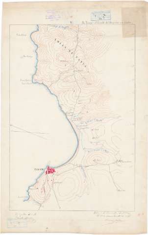
Itinerario] De Tanger al limite del imperio con Ceuta


 Maps, plans and nautical charts
Itinerario] De Tanger al limite del imperio con Ceuta (1882 noviembre 3)
Maps, plans and nautical charts
Itinerario] De Tanger al limite del imperio con Ceuta (1882 noviembre 3)
 Disponible Holdings
 Section: Maps, plans and nautical charts
Uniform title: Marruecos. Itinerarios (1882). 1:20000
Title: Itinerario] De Tanger al limite del imperio con Ceuta / el capitán de E.M. Eduardo Alvarez, el T.C. comandante de E.M. Ramón Jaudenes
Material or type of resouce Area: Escala [ca. 1:20000]
Publication: 1882 noviembre 3
Physical description: 1 mapa en 5 h. : ms., col. ; 60x40 cm en h. de 75x47 cm
Content type: Imagen cartográfica
Media type: computadora
Carrier type: recurso en línea
Notes: Comprende parte de las provincias de Tanger y Tetuán
Manuscrito firmado, rubricado y fechado en Tetuán
A plumilla en tinta negra, azul, siena y roja
Orientado con flecha. Indica ángulo de declinación magnética
Relieve representado por curvas de configuración
Manuscrito sobre tela para planos
Clave alfabética para indicar los tipos de vegetación
Se dispone ademas de 2 copias con sig. Ar.Q-T.8-C.3-90(1) y 90(2)
Materia / lugar / evento: Itinerarios
1882
Tánger (Provincia)
Tetuán
Ceuta
Other authors: Jáudenes, Ramón
Alvarez y Ardanuy, Eduardo, 1849-
UDC: 912:656.02(64-17)'1882'
(64-328 Tanger)
(64-328 Tetuán)
(647.1)
Type of publication:
Maps
Rights:
Préstamo:
Disponible
