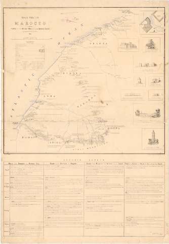
Road sketch in Marocco shewing routes of the British...


 Maps, plans and nautical charts
Road sketch in Marocco shewing routes of the British Mission to the Sultan's Court (Feb. 1888)
Maps, plans and nautical charts
Road sketch in Marocco shewing routes of the British Mission to the Sultan's Court (Feb. 1888)
 Disponible Holdings
 Section: Maps, plans and nautical charts
Uniform title: Marruecos. Itinerarios (1887). 1:633600
Title: Road sketch in Marocco shewing routes of the British Mission to the Sultan's Court / by Lieut : W.A. Boulnois R.A.
Material or type of resouce Area: Escala 1:633600 (O10°10'-O5°50'/N34°00'-N30°50')
Publication: [London ?] : The Intelligence Division, War Office, Feb. 1888
Physical description: 1 mapa : col. ; montado sobre tela ; 57,2x63,7 cm en h. de 95,9x66,3 pleg. en 60,7x50,8
Content type: Imagen cartográfica
Media type: computadora
Carrier type: recurso en línea
Notes: Presenta mapa de detalle y 9 edificios de perfil
Escala gráfica de 50 english statute miles [= 15,2].
Tabla de signos convencionales para indicar, nucleos de población de distinta categoría, estaciones, caminos y puertos
Tabla con las distintas rutas haciendo mención de carreteras, ciudades y pueblos, datos hidrográficos, regiones, ríos y montañas
Materia / lugar / evento: Itinerarios
1887
Other authors: Boulnois, R.A
Gran Bretaña. Intelligence Division
UDC: 912:656.02(64-15)'1888'
64-15
Type of publication:
Maps
Rights:
Préstamo:
Disponible
