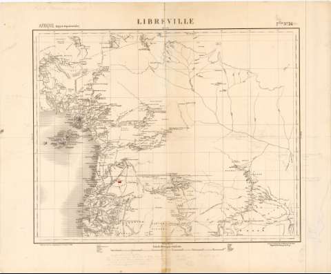
Libreville


Section: Maps, plans and nautical charts
Uniform title: GUINEA (Golfo). Mapas generales. 1:2000000 (1889)
Title: Libreville / Dressé et dessine par le Chef de Bon. du Génie, Regnauld de Lannoy de Bissy
Material or type of resouce Area: Escala 1:2000000 ; [proyec. cilindrica]
Publication: Paris : Publié par le Service Geógraphique de l'Armée, 1889
Physical description: 1 mapa ; 42x52,2 cm en h. de 53x64,8 cm
Content type: Imagen cartográfica
Media type: computadora
Carrier type: recurso en línea
Notes: Comprende los paises de Camerun, Guinea ecuatorial y Gabon
Pertenece al 'Afrique Region equatoriale. Flle. N. 34
Coordenadas referidas al parecer, al meridiano de Paris (E5°30'-E14°30'/N7°10'-N0°00'). Red geográfica de 1° en 1°
Relieve representado por sombreado
Materia / lugar / evento: Mapas generales
1889
Camerún
Guinea Ecuatorial
Gabón
UDC: 912(26.04 Guinea)'1889'
(671.1)
(671.8/.9)
Type of publication:
 Maps
Maps
Rights:
Préstamo:
 Disponible
