New Chart of the Coast of Africa between Cape Formoso and...


 Maps, plans and nautical charts
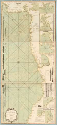
New Chart of the Coast of Africa between Cape Formoso and Cape Negro with the Adjacent Islands (May 1794)
Maps, plans and nautical charts
New Chart of the Coast of Africa between Cape Formoso and Cape Negro with the Adjacent Islands (May 1794)
 Disponible Holdings
 Section: Maps, plans and nautical charts
Uniform title: AFRICA. Cartas náuticas (1794). 1:1700000
Title: New Chart of the Coast of Africa between Cape Formoso and Cape Negro with the Adjacent Islands / Composed from the Draughts, Observations, Journals, & Ca. of Messes Robt. Norris, Willm. Woodville and Archd. Dalzel of Liverpool...
Material or type of resouce Area: [Ca. 1:1700000]
Publication: London : Published by Laurie & Whittle, N 53, Fleet Street 12th, May, 1794
Physical description: 1 carta náutica : col., montada sobre tela ; 154 x 69 cm, pleg. en 51 x 69 cm
Content type: Imagen cartográfica
Media type: computadora
Carrier type: recurso en línea
Notes: Presenta además catorce perfiles, una vista y nueve mapas de detalle
Escala hallada a partir de un grado de latitud [= 6,5 cm]. Coordenadas referidas al meridiano de Londres (E 6º30'-E 17°00'/N 6°30'-S 16°30'). Orientada con lis en rosa de los vientos. Indica ángulo de declinación magnética
Relieve de perfil
Indica veriles, bajos, fondeaderos y sondas batimétricas
Tabla de latitudes
Título enmarcado en cartela
Sello del Depósito de la Guerra
Other authors: Norris, Robert
Woodville, William
Dalzel, Archibald
Robert Laurie and James Whittle
UDC: 912:551.46(6-15)'1794'
6-15
Type of publication:
Maps
Rights:
Préstamo:
Disponible
