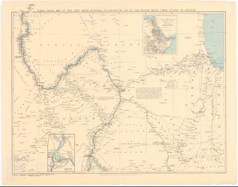
Large Scale Map of The Nile from Dongola to Khartum and...


 Maps, plans and nautical charts
Large Scale Map of The Nile from Dongola to Khartum and of the Desert Roule from Suakin to Berber (1897)
Maps, plans and nautical charts
Large Scale Map of The Nile from Dongola to Khartum and of the Desert Roule from Suakin to Berber (1897)
 Disponible Holdings
 Section: Maps, plans and nautical charts
Uniform title: SUDAN. Mapas generales (1897). 1:1000000
Title: Large Scale Map of The Nile from Dongola to Khartum and of the Desert Roule from Suakin to Berber
Material or type of resouce Area: Escala [ca. 1:1000000], 60 English Miles [= 11 cm] ; [proyec. cilindrica] (E30°50'-E37°45'/N20°40'-N15°0')
Publication: London : Published by Edward Stanford 26 & Cocks Street Charing Cross S.W., 1897
Physical description: 1 mapa : col. ; 63x83,5 cm en h. de 73x92, pleg. en 46x73 cm
Content type: Imagen cartográfica
Media type: computadora
Carrier type: recurso en línea
Notes: Presenta además 2 mapas, 'Khartum' y 'The Nile Basin'
Red geografica de 1° en 1°
Relieve representado por normales
Relación de las diversas rutas indicadas por clave numerica
Nota sobre la carretera de Suakin a Berber
Materia / lugar / evento: Mapas generales
1897
Other authors: Stanford, Edward
UDC: 912(624)'1897'
624
Type of publication:
Maps
Rights:
Préstamo:
Disponible
