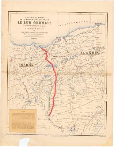
Le Sud Oranais et les parties limitrophes du Marok : á...


 Maps, plans and nautical charts
Le Sud Oranais et les parties limitrophes du Marok : á l'échelle du : 1.600000e. (Aout-Novembre 1881)
Maps, plans and nautical charts
Le Sud Oranais et les parties limitrophes du Marok : á l'échelle du : 1.600000e. (Aout-Novembre 1881)
 Disponible Holdings
 Section: Maps, plans and nautical charts
Uniform title: Argelia. Mapas generales (1881). 1:1600000
Title: Le Sud Oranais et les parties limitrophes du Marok : á l'échelle du : 1.600000e. / par O. Mac Carthy... ; Gravé par A. Martin..
Material or type of resouce Area: 1:600000
Publication: Paris [etc.] : Librairie Ch. Delagrave, 15, Rue Soufflot, Aout-Novembre 1881 ([Paris] : Imp. Dufrenoy)
Physical description: 1 mapa : col. ; 63,5 x 51,5 cm en h. de 75,5 x 58,5 cm, pleg. en 38 x 58,8 cm
Content type: Imagen cartográfica
Media type: computadora
Carrier type: recurso en línea
Notes: Precede al título: "Publié sous les Auspices de la Société de Géographie d'Alger"
Escalas gráficas de 100 kilómetros [= 6,3 cm] y 62 millas inglesas [= 6,3 cm]. Coordenadas referidas al meridiano de París (O 7°30'-E 1°10'/N 37°30'-N 28°40'). Red geográfica de 1° en 1°
Relieve representado por normales
Tabla de signos convencionales para indicar líneas ferroviarias
Nota explicativa sobre la composición del mapa y sobre altitudes de algunos puntos
Procede de la "Colección Coello"
Other authors: MacCarthy, Oscar
Dufrenoy, E
Delagrave, Charles
Martin, A
UDC: 912:341.22(65-15)'1881'
(64-11)
Type of publication:
Maps
Rights:
Préstamo:
Disponible
