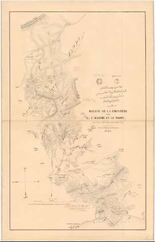
Relevé de la frontiére entre l'Algérie et le Maroc :...


 Maps, plans and nautical charts
Relevé de la frontiére entre l'Algérie et le Maroc : dans le Tel et dans le Sahra jusqu'a Tniet el Sasi (1845)
Maps, plans and nautical charts
Relevé de la frontiére entre l'Algérie et le Maroc : dans le Tel et dans le Sahra jusqu'a Tniet el Sasi (1845)
 Disponible Holdings
 Section: Maps, plans and nautical charts
Uniform title: ARGELIA. NO. Mapas generales. 1:100000 (1845)
Title: Relevé de la frontiére entre l'Algérie et le Maroc : dans le Tel et dans le Sahra jusqu'a Tniet el Sasi / gravée au Dépot général de la Guerre, Schwaerzle sct
Material or type of resouce Area: 1:100000
Publication: Paris : Kaeppelin, Quai Voltaire 15, 1845
Physical description: 1 mapa : montado sobre tela ; 133,4 x 84,7 cm, pleg. en 84,7 x 66,7 cm
Content type: Imagen cartográfica
Media type: computadora
Carrier type: recurso en línea
Notes: Escala gráfica de 4 leguas de 4000 m [= 15,8 cm]. Orientado con flecha
Relieve representado por normales
Nota relativa a que las fronteras señaladas en el mapa responden a la Convención de Delimitación del 18 de marzo de 1845, firmada por el Jefe de Escuadrón de E.M. E. de Martimprey
Entelado en 2 cuarterones
Sello ilegible con firma y rúbrica del Gral. Cte. de la Cruz
Se dispone además de los documentos con signa. SG. Ar.Q-T.10-C.1-10(1) y 10(2) de contenido similar
Materia / lugar / evento: Mapas generales
Fronteras
Itinerarios
Tratados
1845
Marruecos
Argelia
Other authors: Schwaerzlé, J
Francia. Dépôt de la guerre
Kaeppelin et Cie
UDC: 912:[341.222:656.02:341.241](65-16+64-18)'1845'
( 64-18)
Type of publication:
Maps
Rights:
Préstamo:
Disponible
