Carte des Environs D'Ilerda


 Maps, plans and nautical charts
Carte des Environs D'Ilerda (1887)
- Erhard Schièble, Georges, 1821-1880
Maps, plans and nautical charts
Carte des Environs D'Ilerda (1887)
- Erhard Schièble, Georges, 1821-1880
 Disponible Holdings
 Section: Maps, plans and nautical charts
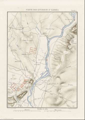
Title: Carte des Environs D'Ilerda / gravé par Erhard Schièble
Author: Erhard Schièble, Georges, 1821-1880
Material or type of resouce Area: Escala 1:40000
Publication: [París] : Imprimerie Nationale, [1887]
Physical description: 1 mapa : col. ; 27x20 cm, en h. de 35x25 cm
Content type: Imagen cartográfica
Media type: computadora
Carrier type: recurso en línea
Notes: Escala gráfica además en 'Kilométres' y 'Milles romains'
Relieve : líneas perpendiculares normales, puntos acotados
Orientado con flechs
Copia digital. España : Ministerio de Cultura y Deporte. Subdirección General de Coordinación Bibliotecaria, 2010
Other titles: En: Histoire de Jules César : Guerre Civile : Planches : [atlas]. - París : Imprimerie Nationale, 1887. - Planche 5
Materia / lugar / evento: Maniobras militares
Batallas
Estrategia
Imperio romano
Lérida
Related titles: Lérida (Provincia). 1887. 1:40.000
UDC: 912:[355.52:625.7:355.43](467.12)'-0053/-0044'
467.12
37
Type of publication:
Maps
Rights:
