Tánger


Section: Maps, plans and nautical charts
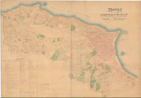
Uniform title: Tánger. Planos topográficos. 1906?. Español. 1:2.000
Title: Tánger / Levantado por el Cpo. de E.M.
Material or type of resouce Area: Escala 1:2.000
Publication: [1906?]
Physical description: 1 plano : col., copia en ozalid, montada sobre tela ; 96,5 x 138 cm
Content type: Imagen cartográfica
Media type: computadora
Carrier type: recurso en línea
Notes: Orientado con flecha
Relieve representado por curvas de nivel, equidistancia 2 metros
Clave de signos convencionales representando tipo de edificios, santuarios, norias, pozos, caminos y vallados
Fecha aproximada de ejecución tomada de una copia manuscrita de este plano
Copia en ozalid, subrayados en tintas roja y azul el relieve y la hidrografía y coloreada en verde, rojo y azul
Inserta: Clave alfanumérica con las iglesias, mezquitas y puntos principales, vocabulario y abreviaturas
Materia / lugar / evento: Planos topográficos
Planos de población
1906
Tánger (Provincia)
Tánger
Tánger-Tetuán (Marruecos, Región)
Marruecos
Other authors: España. Estado Mayor Central
UDC: (64 Tánger)
Type of publication:
 Maps
Maps
Rights:
Préstamo:
 Disponible
