Santander


Section: Maps, plans and nautical charts
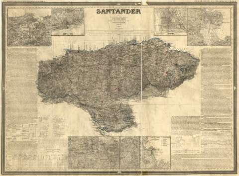
Uniform title: Santander. Mapas generales (1861). Español. 1:200.000
Title: Santander / por el Coronel, Teniente-Coronel de Ingenieros D. Francisco Coello ; las notas estadísticas é históricas han sido escritas por D. Pascual Madoz ; El contorno y la topografía por Leclercq y Lebreton, la letra por Bacot
Material or type of resouce Area: Escala 1:200.000 ; [proy. cónica de Bonne]
Publication: Madrid : D. Francisco Coello, 1861
Physical description: 1 mapa : col., montado sobre tela ; 75,5 x 101 cm
Content type: Imagen cartográfica
Media type: computadora
Carrier type: recurso en línea
Notes: Escala también dada en forma gráfica, de 10 leguas legales o de 20000 pies, 30 millas marítimas de un minuto de latitud, 8 leguas de 17 1/2 al grado o de 22813'16 pies y 50 kilómetros. Coordenadas referidas al meridiano de Madrid (O 1°28'--E 0°54'/N 43°45'--N 42°30')- Red geográfica de 30' en 30'. Mención nominal de los puntos cardinales
Relieve representado por curvas de configuración y puntos acotados expresados en pies castellanos
Indica veriles y bajos en algunos puntos de la costa
Tabla de signos convencionales para indicar, entre otros, núcleos de población de distinta categoría, fortificaciones, capillas, conventos, molinos, telégrafos, caminos, principales accidentes geográficos y límites administrativos (de provincias, partidos, términos municipales y obispados). Figura además otra tabla en la que se relacionan los meridianos más usuales, dando cuenta de los puntos por los que pasan y de sus coordenadas geográficas, respecto al meridiano de Madrid
Consta, en cada uno de los márgenes laterales del documento, amplias leyendas explicativas y tablas estadísticas con abundante información de esta provincia referente a su demografía, división administrativa, censo electoral, instrucción pública, estádística criminal, beneficiencia, culto y clero, sistema tributario, potencial económico (industria, comercio, producción agrícola, etc.) e historia
En nota, se señalan también todos aquellos trabajos tenidos en cuenta para la elaboración del presente documento
Límites administrativos diferenciados con color
En el margen superior: "Diccionario Geográfico-Estadístico-Histórico" y "Atlas de España y sus posesiones de Ultramar"
Inserta: "Contornos de Santander". Escala 1:100000 ; "Contornos de la Cabada" ; "Contornos de Limpias" ; "Ria de S. Martin de la Arena" ; "Contornos de Santona". Escala 1:50000 ; "Población y puertos de Castro-Urdiales". Escala 1:20000 ; "Santoña". Escala 1:10000. Indican sondas batimétricas enbrazas y pies. Clave hidrográfica para determinar la calidada del fondo. En el plano de Castro-Urdiales además, figura una relación de sus principales edificios
Existen cuatro ejemplares, conservándose también, la minuta (de 1860) de esta edición, de sign. SGE-Ar.E-T.5-C.2-25
Consta el sello del Depósito de la Guerra, arreglo de 1895
Materia / lugar / evento: Mapas generales
Puertos
Planos de población
Cartas náuticas
Bahías
Divisiones administrativas
1861
Cantabria (Comunidad Autónoma)
Genre / form: Mapas generales
Other authors: Coello, Francisco, 1822-1898
Bacot, Pierre Adolphe
Madoz, Pascual, 1806-1870
Leclercq, Ch., s. XIX
Lebreton, A
UDC: 912:551.46]+[314(084.3)]+311.2+(1-2/-5)(463.3)"1861"
463.3
Type of publication:
 Maps
Maps
Rights:
Préstamo:
 Disponible
