Map of the world illustrating the principal features of...


 Maps, plans and nautical charts
Map of the world illustrating the principal features of the land and the co - tidal lines (1872)
- Colton, G. Woolworth, 1827-1901
Maps, plans and nautical charts
Map of the world illustrating the principal features of the land and the co - tidal lines (1872)
- Colton, G. Woolworth, 1827-1901
 Disponible Holdings
 Section: Maps, plans and nautical charts
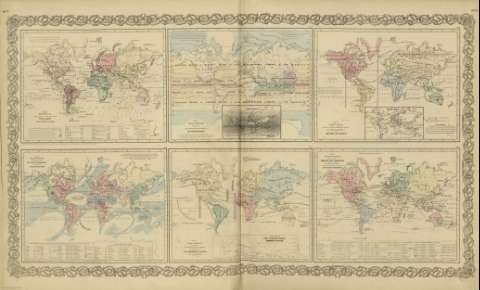
Title: Map of the world illustrating the principal features of the land and the co - tidal lines / [drawn by George Woolworth Colton]
Author: Colton, G. Woolworth, 1827-1901
Material or type of resouce Area: Escala indeterminada (O 180º--E 180º /N 80º--S 70º)
Publication: New York : published by G.W. and C.B. Colton & Co., [1872]
Physical description: 1 mapa : col. ; 17 x 22 cm, en h. de 44 x 36 cm
Content type: Imagen cartográfica
Media type: computadora
Carrier type: recurso en línea
Notes: Incluye leyenda de signos utilizados.
Inserta: List or table lands or plateurs ; Plains or Lowlands.
Con: Map of the world illustrating the principal features of meteorology ; Map of the world showing the geographical distribution & rauge of the principal members of the animal kingdom ; Map of the world showing the principal ocean currents & boundaries of river systems ; Map of the world showing the distribution and limits of cultivation of the principal plants ; Map of the world illustrating the productive industry of various countries & exhibiting the principal features of commerce and navigation.
Copia digital. España : Ministerio de Cultura y Deporte. Subdirección General de Coordinación Bibliotecaria, 2010
Materia / lugar / evento: Declinación magnética
Montañas
Fitogeografía
Mareas
Mundo - Mapas
Other authors: G.W. & C.B. Colton & Co
Related titles: Mundo. Mapas físicos (1872)
UDC: 912:911.2]:[528.02+551.43+581.9+551.466](100)'1872'
100
Type of publication:
Maps
Rights:
