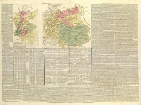
De L'Allemagne Politique en 1812


Section: Maps, plans and nautical charts
Uniform title: Alemania. Mapas políticos. 1827 (1812)
Title: De L'Allemagne Politique en 1812
Material or type of resouce Area: Escala indeterminada
Physical description: 1 mapa : col. ; 52 x 37 cm
Content type: Imagen cartográfica
Media type: computadora
Carrier type: recurso en línea
Notes: Incluye alrededor del mapa una amplia explicación histórica y geográfica sobre la carta
Lugar y fecha de publicación tomada del atlas en el que se encuentra el mapa
Mar de alrededor de las costas sombreado con un fino rayado
Meridianos y paralelos formando cuadrícula
Núcleos de población destacando los más importantes
Copia digital. Madrid : Ministerio de Cultura, 2010
Incluye en el margen izquierdo del mapa: "Allemagne Legislative: Tableau des Estats devant voter dans les 3 Colleges de L'Empire d'après les changemts. arrétés sous la mediation de la France et de la Russie en 1803"
Other titles: En: Atlas historique, généalogique, chronologique et géographique de A. Lesage (Comte de Las Cases). - Paris : Leclère, Libraire, 1827. - [Mapa 12]
Materia / lugar / evento: Mapas históricos
Divisiones administrativas
Imperios
Geografía histórica
Historia
1803
1812
Alemania
UDC: (430)
Type of publication:
 Maps
Maps
Rights:
