Bahía de La Granja


 Disponible Holdings
 Section: Maps, plans and nautical charts
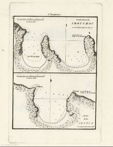
Title: Bahía de La Granja
Author: España. Dirección de Hidrografía
Material or type of resouce Area: Escala: [1:24.450], 4 cables [= 3,2 cm] (N 19°52'51''--O 71°37'48'')
Publication: [Madrid] : Dirección de Hidrografía, [1809]
Physical description: 1 carta náutica ; 30 x 21 cm
Content type: Imagen cartográfica
Media type: computadora
Carrier type: recurso en línea
Notes: Presenta la bahía desde la punta Palmista hasta la punta Oriental.
Indica coordenadas referidas al meridiano de Cádiz: Lat. N 19º52' Long. 66º18. O. de Cad. Orientado con media lis.
Relieve representado por sombreado y de perfil.
Indica sondas batimétricas e isolíneas de batimetría.
Señala la profundidad de las sondas en brazas.
Copia digital . España : Ministerio de Cultura y Deporte. Subdirección General de Coordinación Bibliotecaria, 2010
Contains: Fondeadero de Chouchou
Other titles: En: Portulano de la America Setentrional : dividido en quatro partes. - Madrid : Dirección de Hidrografía, 1809. - Parte cuarta. Santo Domingo Nº5
Materia / lugar / evento: Bahías - Mapas
Caribe (Mar) - Cartas náuticas
La Granja (República Dominicana, Ensenada)
Related titles: GRANJA (República Dominicana) (Bahía). Bahías (1809)
Type of publication:
 Maps
Maps
Rights:
