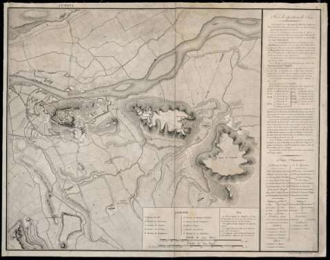
Lerida


Section: Maps, plans and nautical charts
Uniform title: LÉRIDA. Planos de población. 1:10.000 (1813)
Title: Lerida / Gravé par E. Collin
Material or type of resouce Area: Escala [ca. 1:10.000]. 800 toesas [=15,1 cm]
Publication: [France : [Editor no identificado], 1813]
Physical description: 1 plano : montado sobre tela ; 44 x 56 cm
Content type: Imagen cartográfica
Media type: computadora
Carrier type: recurso en línea
Notes: Comprende Lérida y sus alrededores en un radio apróximado de 2 km
Fecha tomada del catálogo del SGE: "Cataluña. Provincias de Tarragona y Lérida. Siglos XVII a XIX". 1970, p. 411
Orientado al norte geográfico
Relieve representado por normales
Relación de las principales fortificaciones indicada por clave alfabética
Explicación detallada del sitio de la ciudad
Nota informando del estado de las fuerzas de la guarnición y del ejército enemigo así como otra señalando los movimientos de los mismos
En el margen superior: "4"
Materia / lugar / evento: Planos de población
Estrategia militar
Fortificaciones
Operaciones bélicas
Guerras de independencia
1813
Lérida
Cataluña
España
España - Historia - 1808-1814 (Guerra de la Independencia)
Other authors: Collin, Etienne
UDC: 912:[314(084.3)]:623.1+355.43(467.121.4-2)"1813"
467.121.4-2
Type of publication:
 Maps
Maps
Rights:
Préstamo:
 Disponible
