Canalis inter Angliae et Galliae Littora = Pafcaert van't...


 Maps, plans and nautical charts
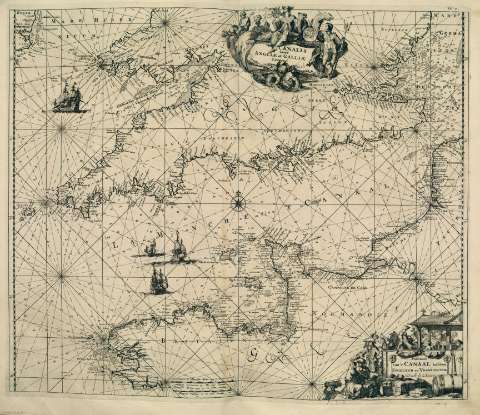
Canalis inter Angliae et Galliae Littora = Pafcaert van't Canaal tuffchen Engeland en Vranckryck (1715)
Maps, plans and nautical charts
Canalis inter Angliae et Galliae Littora = Pafcaert van't Canaal tuffchen Engeland en Vranckryck (1715)
 Disponible Holdings
 Section: Maps, plans and nautical charts
Uniform title: Canal de la Mancha. Cartas náuticas. 1715
Title: Canalis inter Angliae et Galliae Littora = Pafcaert van't Canaal tuffchen Engeland en Vranckryck
Other titles: Pafcaert van't Canaal tuffchen Engeland en Vranckryck
Material or type of resouce Area: Escala [ca. 1.172.675]. Geometrische of Duytsche Mylen van 15 in een Graad [= 7,58 cm]
Publication: [Amsterdam] : Gedruckt by L. Renard, [1715]
Physical description: 1 cara náutica ; 51 x 59 cm
Content type: Imagen cartográfica
Media type: computadora
Carrier type: recurso en línea
Notes: Copia digital. Madrid : Ministerio de Cultura, 2010
Other titles: En: Atlas de la Navigation, et du Commerce qui se fait dans toutes les parties du Monde. - A Amsterdam : Chez Louis Renard, Marchand Libraire, 1715. - Lámina 12
Materia / lugar / evento: Canal de la Mancha - Cartas náuticas
Francia - Costas - Cartas náuticas
Inglaterra - Costas - Cartas náuticas
Genre / form: Cartas náuticas
Other authors: Jauffret, Louis-François, 1770-1850
UDC: (261.268)
Type of publication:
Maps
Préstamo:
 Disponible sólo para consulta en sala
