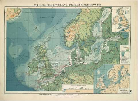
The North Sea and the Baltic-cables and wireless stations


 Maps, plans and nautical charts
The North Sea and the Baltic-cables and wireless stations (1922)
- Philip, George, 1870-1937
Maps, plans and nautical charts
The North Sea and the Baltic-cables and wireless stations (1922)
- Philip, George, 1870-1937
 Disponible Holdings
 Section: Maps, plans and nautical charts
Title: The North Sea and the Baltic-cables and wireless stations
Author: Philip, George, 1870-1937
Material or type of resouce Area: Escala 1:12.500.000
Publication: [London] ; [Liverpool] : George Philip & Son, Ltd : The London Geographical Institute : Philip, Son & Nephew, [1922]
Physical description: 1 mapa ; 36 x 49 cm
Content type: Imagen cartográfica
Media type: computadora
Carrier type: recurso en línea
Notes: Copia digital. Madrid : Ministerio de Cultura, 2010
Inserta: the North Sea & the Baltic showing visibility of Land ; A section across the North Sea and the Baltic ; Gran Bretaña
Other titles: En: Philip's Mercantile Marine Atlas. - [London] : Edited by George Philip [et al.], 1922. - Mapa 30
Materia / lugar / evento: Instalaciones de telecomunicación - Mapas
Mar del Norte - Mapas
Báltico - Mapas
Genre / form: Atlas mundiales
Other authors: George Philip & Son
Merchant, Shippers, Exported and Ocean Travelles
London Geographical Institute
UDC: (261.26)
(261.24)
Type of publication:
Maps
Rights:
Préstamo:
 Disponible sólo para consulta en sala
