A Chart of the Harbour of Rhode Island and Narragansett bay


 Maps, plans and nautical charts
A Chart of the Harbour of Rhode Island and Narragansett bay (1776)
- Des Barres, Joseph F. W (Joseph Frederick Wallet), 1722-1824
Maps, plans and nautical charts
A Chart of the Harbour of Rhode Island and Narragansett bay (1776)
- Des Barres, Joseph F. W (Joseph Frederick Wallet), 1722-1824
 Disponible Holdings
 Section: Maps, plans and nautical charts
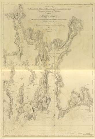
Title: A Chart of the Harbour of Rhode Island and Narragansett bay / Surveyed in pursuance of directions from the Lords of Trade to his Majesty Surveyor General for the Northern Discrict of North America ; Published at the Request of the Right Honourable Lord Viscount Howe ; by J.F.W. Des Barres Esq 20 th July 1776 ; [Ashby Script et Tomkins Sculpt]
Material or type of resouce Area: Escala [ca. 1:51000] (O 71° 26' 30'' -- O 70° 59' 55'' / N 41° 51' 45'' -- N 41° 22' 58'')
Publication: [London?] : Des Barres, 1776
Physical description: 1 mapa ; 107 x 74 cm
Content type: Imagen cartográfica
Media type: computadora
Carrier type: recurso en línea
Notes: Charts of the coast and harbors of New England, Nº 24
Documento graduado, longitud tomada respecto del meridiano de Greenwich
Consta escala gráfica de 6 millas legales, [= 18,9 cm]
Orientado con lis, indicando variación magnética
Presenta análisis batimétrico
Describe detalladamente la toponimia costera
Other authors: Ashby, Harry, 1744-1818
Tomkins, Thomas, 1743-1816
UDC: 912:551.46]:627.22:551.468(745)"17"
745:26.04 Rhode Island
Type of publication:
Maps
Rights:
Préstamo:
 Disponible sólo para consulta en sala
