Atlas des vents et des Courants dans l'Ocean Atlantique


 Maps, plans and nautical charts
Atlas des vents et des Courants dans l'Ocean Atlantique (1870)
- Le Gras, Alexandre
Maps, plans and nautical charts
Atlas des vents et des Courants dans l'Ocean Atlantique (1870)
- Le Gras, Alexandre
 Disponible Holdings
 Section: Maps, plans and nautical charts
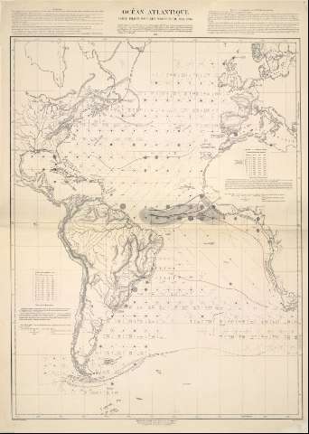
Title: Atlas des vents et des Courants dans l'Ocean Atlantique / Le chef du service de instruction, A. Le Gras
Author: Le Gras, Alexandre
Material or type of resouce Area: [Ca. 1:2222222]
Publication: [París] : Dépôt des Cartes et Plans de la Marine, 1870
Physical description: 1 Atlas ([6h]) : 4 cartas náuticas ; 71 x 53 cm
Content type: Imagen cartográfica
Media type: computadora
Carrier type: recurso en línea
Notes: Título tomado de la cubierta
La mención de responsabilidad está tomada de la contracubierta en donde hay una nota advirtiendo lo que contiene el Atlas
La nota de la contracubierta dice que este atlas comprende cinco cartas, pero solamente hay 4 mapas
Figura sello del Museo Naval
Precede al título: Nº 472
Copia digital. Madrid : Ministerio de Cultura. Dirección General del Libro, Archivos y Bibliotecas, 2010
Included records: Océan Atlantique : Carte pilote pour les mois d'avril, mai, juin. - París : Depot des Cartes et Plans, 1870
Ocean atlantique, ses différents courants, température de la surface . - [París] : Dépot des Cartes et Plans de la Marine, 1870
[...] Ver todos los registros incluidos (4)
Other authors: Francia. Dépôt des Cartes et Plans de la Marine
Related titles: Atlántico (Océano). Cartas náuticas. 1:2.222.222 (1870)
UDC: 912:551.55(084.4)(261)"1870"
(261)
Type of publication:
Maps
Rights:
Préstamo:
 Disponible sólo para consulta en sala
