La Côte depuis Cap Malabar jusqu'au Détroit de Longue Isle


 Maps, plans and nautical charts
La Côte depuis Cap Malabar jusqu'au Détroit de Longue Isle (1780)
- Des Barres, Joseph F. W (Joseph Frederick Wallet), 1722-1824
Maps, plans and nautical charts
La Côte depuis Cap Malabar jusqu'au Détroit de Longue Isle (1780)
- Des Barres, Joseph F. W (Joseph Frederick Wallet), 1722-1824
 Disponible Holdings
 Section: Maps, plans and nautical charts
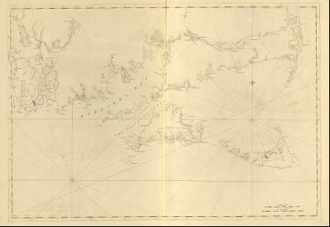
Title: La Côte depuis Cap Malabar jusqu'au Détroit de Longue Isle / J.F.W. Des Barres ; [Tomkins Scripsir, H. Ashby Sculpsit]
Material or type of resouce Area: Escala [ca. 1:131000] (O 71° 25' 10'' -- O 69° 48' 00'' / N 41° 52' 30'' -- N 41° 01' 58'')
Publication: [LOndon?] : J. F. W. Des Barres, 1780
Physical description: 1 mapa ; 74 x 107 cm
Content type: Imagen cartográfica
Media type: computadora
Carrier type: recurso en línea
Notes: Charts of the coast and harbors of New England, Nº 20
Título propio tomado del ínidce del volúmen, siendo común para la h. no. 21
Graduado, longitud respecto del meridiano de Greenwich
Contiene dos escalas gráficas, una de diez millas legales, [= 12,2 cm], y otra de diez millas naúticasde [= 14,2 cm]
Orientado con lis
Aparecen trazados nudos de rumbos
Other titles: En: The Atlantic Neptune. - [London?] : J. F. W. Des Barres, 1774- 1780
Other authors: Ashby, Harry, 1744-1818
Tomkins, Thomas, 1743-1816
Related titles: Massachusetts (Estados Unidos). Cartas náuticas. 1:131000 (1780)
UDC: 912:551.46]:551.468:551.42(744)"17"
744-13
Type of publication:
Maps
Préstamo:
 Disponible sólo para consulta en sala
Préstamo:
Disponible sólo para consulta en sala
