The Bay of Chignecto, Petcudiac river, Shepody Bay,...


 Maps, plans and nautical charts
The Bay of Chignecto, Petcudiac river, Shepody Bay, Cumberland Bason, Apple River, Macan, Napan, Memramcook rivers, &c (1779)
- Des Barres, Joseph F. W (Joseph Frederick Wallet), 1722-1824
Maps, plans and nautical charts
The Bay of Chignecto, Petcudiac river, Shepody Bay, Cumberland Bason, Apple River, Macan, Napan, Memramcook rivers, &c (1779)
- Des Barres, Joseph F. W (Joseph Frederick Wallet), 1722-1824
 Disponible Holdings
 Section: Maps, plans and nautical charts
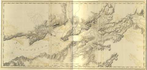
Title: The Bay of Chignecto, Petcudiac river, Shepody Bay, Cumberland Bason, Apple River, Macan, Napan, Memramcook rivers, &c / J.F.W. Des Barres ; [Tomkins Scriplit, H. Ashby Sculpsit]
Material or type of resouce Area: Escala [ca. 1:58700] (O 64°45'--O 63°40'/N 45°46'--N 45°25')
Publication: [London?] : J.F.W. Des Barres, 1779
Physical description: 1 mapa : col. ; 75 x 159 cm, pleg. 80 x 56 cm
Content type: Imagen cartográfica
Media type: computadora
Carrier type: recurso en línea
Notes: The Sea Coast of Nova Scotia, Nº 5
Carta náutica de la bahía de Chignécto, y de los principales ríos en torno a ella, en la que se determina la batimetría de sondas y veriles y calidad del fondo de la misma
Graduado respecto al meridiano de Greewnwich y con escalas gráficas en millas legales y náuticas
Orientado con dos nudos de 32 rumbos, uno de ellos con lis y mostrando el ángulo de declinación magnética
Toponimia de bahías y ríos y orografía de normales
Presenta signos convencionales que informan sobre las mareas, corrientes, etc., y que están referidos al índice del primer mapa de este mismo volumen
Título propio tomado de la relación de documentos que presenta el volumen
Other titles: En: The Atlantic Neptune. - [London?] : J. F. W. Des Barres, 1774- 1780. - 5
Other authors: Ashby, Harry, 1744-1818
Tomkins, Thomas, 1743-1816
Related titles: NUEVA ESCOCIA (Canadá). Cartas náuticas. 1:58700 (1779)
UDC: 912:551.46]:551.468:556.53(716)"1779"
716
Type of publication:
Maps
Rights:
Préstamo:
 Disponible sólo para consulta en sala
