A Chart of Nova Scotia


 Maps, plans and nautical charts
A Chart of Nova Scotia (1775)
- Des Barres, Joseph F. W (Joseph Frederick Wallet), 1722-1824
Maps, plans and nautical charts
A Chart of Nova Scotia (1775)
- Des Barres, Joseph F. W (Joseph Frederick Wallet), 1722-1824
 Disponible Holdings
 Section: Maps, plans and nautical charts
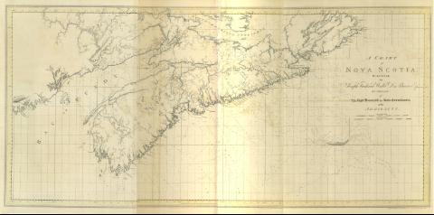
Title: A Chart of Nova Scotia / Surveyed by Joseph Frederick Wallet Des Barres by Order of the Right Honorable the Lords Commissioners of the Admiralty ; [Tomkins Scripst., H. Ashby Scalpsit]
Material or type of resouce Area: Escala [ca. 1:516300] ; proy. Mercator (O 68°0'--O 58°12'/N 46°16'--N 43°2')
Publication: [London?] : J. F. W. Des barres, 1775
Physical description: 1 mapa : col. ; 74 x 152 cm, pleg. 80 x 55 cm
Content type: Imagen cartográfica
Media type: computadora
Carrier type: recurso en línea
Notes: The Sea Coast of Nova Scotia, Nº 2
Carta náutica de Nueva Escocia en la que se determinan números de sonda, veriles, y calidad de fondos de sus costas
Graduado respecto al meridiano de Greenwich y con escalas gráficas en milla legales y millas náuticas
Costas lavadas en azul y orografía de normales
Toponimia costera de accidentes geográficos, completada con posterioridad a la elaboración del documento
Consta de indicadores numéricos y alfabéticos que explican el contenido científico del documento de acuerdo con el índice que presenta la primera hoja de su mismo volumen, y que informan del carácter y naturaleza de las mareas, corrientes, tipos de sonda y variación magnética
Other titles: En: The Atlantic Neptune. - [London?] : J. F. W. Des Barres, 1774- 1780. - 2
Other authors: Ashby, Harry, 1744-1818
Tomkins, Thomas, 1743-1816
Related titles: NUEVA ESCOCIA (Canadá). Cartas náuticas. 1:516300 (1775)
UDC: 912:551.46(716)"1775"
716
Type of publication:
Maps
Rights:
Préstamo:
 Disponible sólo para consulta en sala
