Plano del Castillo de Castell Ciudad


 Maps, plans and nautical charts
Plano del Castillo de Castell Ciudad (1812)
- Justis, Francisco José
Maps, plans and nautical charts
Plano del Castillo de Castell Ciudad (1812)
- Justis, Francisco José
 Disponible Holdings
 Section: Maps, plans and nautical charts
Title: Plano del Castillo de Castell Ciudad / Franco. José Justiz
Author: Justis, Francisco José
Material or type of resouce Area: Escala [ca. 1:400]. 60 varas [=12,7 cm]
Publication: [Lugar de publicación no identificado] : [Editor no identificado], [1812]
Physical description: 1 plano : ms., col., montado sobre tela ; 49,8 x 79,5 cm
Content type: Imagen cartográfica
Media type: computadora
Carrier type: recurso en línea
Notes: Manuscrito firmado y rubricado por el autor. A plumilla en tinta negra y coloreado a la acuarela en verde, carmín y siena
Fecha tomada del catálogo del SGE: "Cataluña. Provincias de Tarragona y Lérida. Siglos XVII a XIX". 1970, p. 460
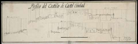
Relación de las dependencias existentes en el castillo (plaza de armas, cuarteles, cisterna de ladrillos, baluartes, cocinas, etc), indicada por clave alfabética
Incluye:"Perfiles del Castillo de Castell Ciudad". Escala para los tres perfiles representados [ca. 1: ]. 60 varas [= cm], en la signatura SGE-Ar.F-T.9-C.3-456(2)
Materia / lugar / evento: Fortificaciones
Castellciutat
Nombre jerárquico lugar: España - Cataluña - Lérida - Castellciutat
Other authors: España. Cuerpo de Ingenieros del Ejército
Related titles: CASTELLCIUTAT (Lérida). Castillos. 1:400 (1812)
UDC: 912:623.6:623.1:744.4(467.121.5)"1812"
467.121.5 Castellciutat
Type of publication:
Maps
Rights:
Préstamo:
Disponible
