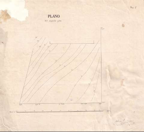
Plano del segundo patio [del Castillo del Seboruco en...


 Maps, plans and nautical charts
Plano del segundo patio [del Castillo del Seboruco en Baracoa] (186-?)
Maps, plans and nautical charts
Plano del segundo patio [del Castillo del Seboruco en Baracoa] (186-?)
 Disponible Holdings
 Section: Maps, plans and nautical charts
Title: Plano del segundo patio [del Castillo del Seboruco en Baracoa] / Antonio P. de Comasema
Material or type of resouce Area: Escala 1:100
Publication: 186-?]
Physical description: 1 plano : ms. ; 43.0 x 48.0 cm
Content type: Imagen cartográfica
Media type: computadora
Carrier type: recurso en línea
Notes: Presenta un mapa topográfico que muestra las curvas de nivel, equidistantes un pie, existentes en el terreno ocupado por el segundo patio del mencionado castillo
Título completado a partir de los documentos con los que se relaciona
Firmado y rubricado por el autor
Escala también dada en forma gráfica de 100 [pies de Burgos]
Fecha deducida de otros documentos realizados por el autor
Indica, a lo largo del contorno del patio, las cotas altimétricas que marcan el desnivel de cada uno de los tramos
En el ángulo superior derecho: "Hoja 4a."
Documento relacionado con el de sign. SH+13104/4-13/6 que muestra el mismo plano y con los de sign. SH+13104/4-13/4 y 5 que corresponden, cada uno de ellos, a un perfil y un mapa topográfico del terreno sobre el que se asienta este castillo
Other authors: Palou de Comasema, Antonio
UDC: 729.16 Baracoa
Type of publication:
Maps
Rights:
Préstamo:
Disponible
