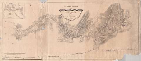
Plano y perfil del Ferro-Carril del Cobre


 Disponible Holdings
 Section: Maps, plans and nautical charts
Uniform title: EL COBRE (Cuba). Líneas ferroviarias. 1845. 1:12103 (1843-1844)
Title: Plano y perfil del Ferro-Carril del Cobre / Construido en 1843 y 1844 Por Julio Sagebien Ingeniero civil ; Promobido [sic] por D. Joaquin de Arrieta Y Dedicado al Exmo. Sor. Conde de Villanueva
Material or type of resouce Area: Escala [ca. 1:12103], 6000 [i.e. 5000] pies ingleses [= 12'6 cm]
Publication: Habana : Litografiado por Francisco A. Callejas, Febrero de 1845
Physical description: 1 mapa ; 41 x 99 cm
Content type: Imagen cartográfica
Media type: computadora
Carrier type: recurso en línea
Notes: Comprende el terreno situado entre la ciudad de El Cobre y la punta de Sal, en la bahía de Santiago de Cuba, por donde discurre el arroyo de El Cobre y la línea ferroviaria paralela al mismo
Escala para las distancias verticales [ca. 1:1220], 300 pies ingleses [= 7'5 cm]. Orientado con flecha
Relieve por normales
Señala, en el perfil, cotas altimétricas que marcan el desnivel de cada uno de los tramos, la distancia existente entre distintos puntos de éstos y la inclinación de las pendientes, así como las millas de que consta su recorrido
Inserta: "Plano de la Bahía de Santiago de Cuba / Copiado de J. W. Norie". Escala [ca. 1:59737], 2 Millas [geográficas] [= 6'2 cm]. Orientado con flecha. Relieve por normales
Materia / lugar / evento: Líneas ferroviarias
Perfiles
Mapas generales
Bahías
Sal (Cuba) (Punta)
Other authors: Sagebien, Julio
Norie, John William
Callejas, Francisco Antonio
UDC: 729.16 El Cobre
729.16-12
Type of publication:
 Maps
Maps
Rights:
Préstamo:
Disponible
