Carta geo-coro-hidro-topografica del Departamento...


 Maps, plans and nautical charts
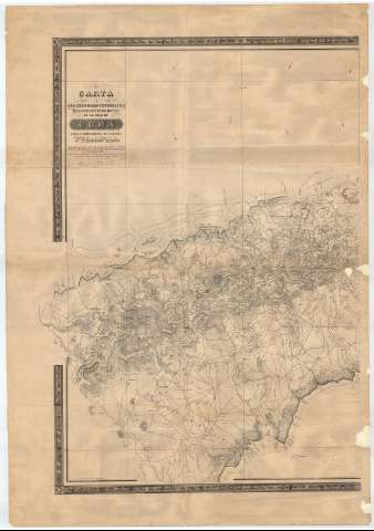
Carta geo-coro-hidro-topografica del Departamento Occidental [sic] de la isla de Cuba hasta el límite oriental de N.... (1853?)
Maps, plans and nautical charts
Carta geo-coro-hidro-topografica del Departamento Occidental [sic] de la isla de Cuba hasta el límite oriental de N.... (1853?)
 Disponible Holdings
 Section: Maps, plans and nautical charts
Uniform title: Cuba. Mapas generales. 1:108932 (1853?)
Title: Carta geo-coro-hidro-topografica del Departamento Occidental [sic] de la isla de Cuba hasta el límite oriental de N. Filipinas / por D. Esteban Pichardo, abogado, miembro de la Comisión Superior de Estadística y Secretario de la Division territorial de la misma isla ; M. Mendez lit.
Material or type of resouce Area: Escala [ca. 1:108932]
Publication: [Cuba] : litog. del Comercio, Obispo No. 42, [1853?]
Physical description: 1 mapa en 4 h. ; en h. de 103 x 70 cm o menor
Content type: Imagen cartográfica
Media type: computadora
Carrier type: recurso en línea
Notes: Bajo el título: "Publicarse en cuatreo hojas co su Memoria justificativa impresa, bajo los auspicios del Exmo. Sor. Capitan Gral."
Escala hallada a partir de 1 minuto de latitud [= 1'7 cm]. Coordendas referidas al meridiano de Cádiz
Relieve por normales
Fecha por normales
Fecha deducida de otros documentos realizados por el autor
Indica sondas e isolíneas batimétricas, bajos, líneas de derrota y la dirección de las corrientes
Documento enmarcado con motivos geométricos
Materia / lugar / evento: Mapas generales
Cartas náuticas
Other authors: Pichardo, Esteban, 1799-1879
Méndez, M
Litografía é Imprenta del Comercio (La Habana)
UDC: 729.1
Type of publication:
Maps
Rights:
Préstamo:
Disponible
