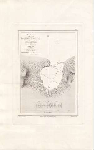
Plano del Puerto de Navas
Section: Maps, plans and nautical charts
Title: Plano del Puerto de Navas / levantado en 1867 por la Comisión hidrográfica al mando del Teniente de Navio D. Agustin Serrano Mayoral ; J. Riudavets lo grabó, S. Bregante go. la letra
Material or type of resouce Area: Escala [ca. 1:5103], 4 cables [= 14'5 cm]
Publication: Madrid : Dirección de Hidrografía, 1874
Physical description: 1 carta náutica ; 29 x 21 cm
Content type: Imagen cartográfica
Media type: computadora
Carrier type: recurso en línea
Series: (Isla de Cuba ; 391)
Notes: Coordenadas del punto A referidas al meridiano de San Fernando (O 68°34'27''/N 20°29'33''). Orientado con estrella en nudo de cuatro rumbos
Relieve por normales y por el dibujo convencional de la forma del roquedo
Indica sondas batimétricas expresadas en metros
Clave hidrográfica para determinar la calidad del fondo
Consta una tabla de reducción de metros a brazas y a pies
Figura el sello en seco de la Dirección de Hidrografía
Materia / lugar / evento: Cartas náuticas
Batimetría
Other authors: Serrano Mayoral, Agustín
Riudavets, José, 1840-1902
Bregante y Martínez, S
España. Comisión Hidrográfica
UDC: (729.16 Navas)
Type of publication:
![]() Maps
Maps
Préstamo:
![]() Disponible
Disponible


