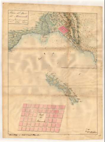
Plano del Puerto del Manzanillo


Section: Maps, plans and nautical charts
Title: Plano del Puerto del Manzanillo / su Autor D. franco. Plazaola ; Es copia Evaristo Carrillo
Material or type of resouce Area: Escala [ca. 1:15597], 2500 varas castellanas [= 13'4 cm]
Publication: [1820?]
Physical description: 1 carta náutica : ms., col. ; 66.0 x 49.2 cm
Content type: Imagen cartográfica
Media type: computadora
Carrier type: recurso en línea
Notes: Comprende la rada de Manzanillo, presentando además el plano de la ciudad del mismo nombre
Firmado y rubricado por el autor de la copia
Orientado con media lis
Relieve por sombreado. Sondas batimétricas
Fecha del original: "año de 1820"
Clave hidrográfica para determinar la calidad del fondo
Toponimia de los caminos, haciendas rurales y principales accidentes geográficos costeros
Lavado en verde, siena, azul y carmín
En el verso figuran el títuo, fecha y autor del original
Documento relacionado con el de sign. SH+13444/5-7/5 y 6, que son otras copias del original
Materia / lugar / evento: Cartas náuticas
Radas
Other authors: Plazaola, Francisco P
Carrillo, Evaristo
UDC: 729.16-11
Type of publication:
 Maps
Maps
Rights:
Préstamo:
 Disponible
