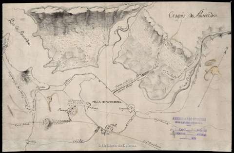
Croquis de Pontevedra


Section: Maps, plans and nautical charts
Uniform title: PONTEVEDRA. Planos de población (1810-1814?). 1:4.320
Title: Croquis de Pontevedra / [Cuerpo de Estado Mayor del Ejército]
Material or type of resouce Area: Escala [ca. 1:4.320]
Publication: [1810-1814?]
Physical description: 1 mapa : ms., montado sobre tela ; 23,9 x 36,7 cm
Content type: Imagen cartográfica
Media type: computadora
Carrier type: recurso en línea
Notes: Comprende la ciudad de Pontevedra y sus alrededores en una distancia aproximada de 7 km
Manuscrito a plumilla en tinta negra
Se inscribe dentro de los reconocimientos efectuados por el V y VI Ejércitos del Cuerpo de Estado Major del Ejército durante los años 1810-1814
Escala hallada de la mención de la longitud total del puente de la ría, de 217 varas castellanas [= 4,2 cm]. Orientado con flecha, aún cuando lo esté de forma incorrecta
Relieve representado por curvas de configuración
Localiza los principales núcleos de población de los alrededores de la ciudad de Pontevedra, de la que se señalan sus edificios religiosos más notables
Materia / lugar / evento: Planos de población
Edificios religiosos
Guerras de independencia
S.XIX
Pontevedra (Provincia)
Galicia
España
España - Historia - 1808-1814 (Guerra de la Independencia)
Genre / form: Manuscritos
Other authors: España. Estado Mayor Central
UDC: 912:726(461.151.6-2)"1810/1814"
461.151.6-2
Type of publication:
 Maps
Maps
Rights:
Préstamo:
 Disponible
