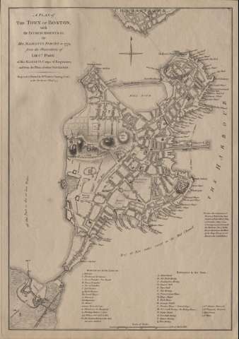
A Plan of the Town of Boston : With the Intrenchments & C...


 Maps, plans and nautical charts
A Plan of the Town of Boston : With the Intrenchments & C. of His Majestys Forces in 1775 from the Observations of... (1777)
Maps, plans and nautical charts
A Plan of the Town of Boston : With the Intrenchments & C. of His Majestys Forces in 1775 from the Observations of... (1777)
 Disponible Holdings
 Section: Maps, plans and nautical charts
Title: A Plan of the Town of Boston : With the Intrenchments & C. of His Majestys Forces in 1775 from the Observations of Lieut. Page of His Majesty's Corps of Engineers ; and from the Plans of other Gentlement / Engraved for Wm. Faden
Material or type of resouce Area: Escala [ca. 1:9.500], 800 yards [= 8,3 cm]
Publication: London : Wm. Faden, Charing Cross, as the Act directs, 1777
Physical description: 1 mapa ; 45 x 31 cm
Content type: Imagen cartográfica
Media type: computadora
Carrier type: recurso en línea
Notes: Orientado con media lis en rosa de 4 vientos
Relieve representado por normales
Relación de las principales confluencias y calles de la ciudad y de las principales baterías flotantes, cañones, etc. "to the Lines & c." indicados por clave alfabética
Nota sobre la evacuación de "Fort-Hill"
Materia / lugar / evento: Operaciones bélicas
Massachusetts
Boston
Other authors: Faden, William, 1749-1836
UDC: 744 Boston
Type of publication:
Maps
Rights:
Préstamo:
Disponible
