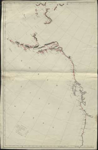
Map exhibiting all the news discoveries in the Interior...


 Maps, plans and nautical charts
Map exhibiting all the news discoveries in the Interior Parts of North America,... (1795)
Maps, plans and nautical charts
Map exhibiting all the news discoveries in the Interior Parts of North America,... (1795)
 Disponible Holdings
 Section: Maps, plans and nautical charts
Title: Map exhibiting all the news discoveries in the Interior Parts of North America,... / A. Arrowsmith
Material or type of resouce Area: [ca. 1:4.400.000], 240 geometrical miles [= 10 cm] ( (O 175°-O 40°/N 70°-N 40°)
Publication: London : Published by A.Arrowsmith, Charles Street, Soho Square, 1795
Physical description: 1 mapa en 3 h. : col. ; en h. de 92 x 56 cm
Content type: Imagen cartográfica
Media type: computadora
Carrier type: recurso en línea
Notes: Relieve representado por sombreado
Nota explicativa que contiene los nombres de aquellos que descubrieron el área representada
Notas explicativas sobre la anchura, profundidad, y demás detalles de los ríos comprendidos en esta zona
Adición superpuesta al mapa con trozos y anotaciones a lápiz, que presenta las mismas características que éste
Proyección cónica simple
Materia / lugar / evento: Descubrimientos geográficos
Canadá
Estados Unidos
América del Norte
Other authors: Arrowsmith, Aaron, 1750-1823
UDC: 7
Type of publication:
Maps
Rights:
Préstamo:
Disponible
