A map of the most inhabited part of New Hampshire, with...


 Maps, plans and nautical charts
A map of the most inhabited part of New Hampshire, with de colonies of Conneticut and England : containing the... (1794.)
Maps, plans and nautical charts
A map of the most inhabited part of New Hampshire, with de colonies of Conneticut and England : containing the... (1794.)
 Disponible Holdings
 Section: Maps, plans and nautical charts
Uniform title: Estados Unidos. NE. Divisiones administrativas. 1:450000 (1794)
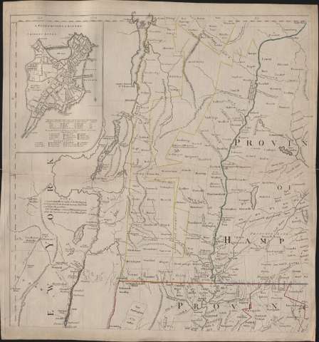
Title: A map of the most inhabited part of New Hampshire, with de colonies of Conneticut and England : containing the Provinces of Massachusets Bay and New Hampshire, with the Colonies of Conecticut and Rhode Island : Divided Counties and Town ships
Material or type of resouce Area: Escala [ca. 1:450.000] into, 8 english marine leagues [= 10 cm]
Publication: London : Laurie & Whittle, 1794.
Physical description: 1 mapa en 4 hojas : col. ; h. de 55 x 52 cm
Content type: Imagen cartográfica
Media type: computadora
Carrier type: recurso en línea
Notes: Presenta además un plano de la ciudad de Boston
Escala gráfica de 30 millas inglesas [= 10'8 cm]. Coordenadas referidas, al parecer, al meridiano de Londres (O 56°30'-O 51°30'/N 44°30'-N 40°30'). Red geográfica de 30' en 30'. Orientado con lis en rosa de 4 vientos
Notas explicativas sobre la orografía e hidrografía que contiene el documento
Indica los condados y términos municipales de las provincias que comprende
Señala los límites provinciales en varios colores
Título enmarcado en cartela que incluye además una litografía de Plymouth
Inserta: A plan of Boston Harbor from an Accurate Survey.- Escala [ca. 1:160000], 4 miles [= 4'5 cm]
Materia / lugar / evento: Divisiones administrativas
Estados Unidos
Other authors: Robert Laurie and James Whittle
UDC: 73
Type of publication:
Maps
Rights:
Préstamo:
Disponible
