A New and General Map of the Middle Dominions Belonging...


 Maps, plans and nautical charts
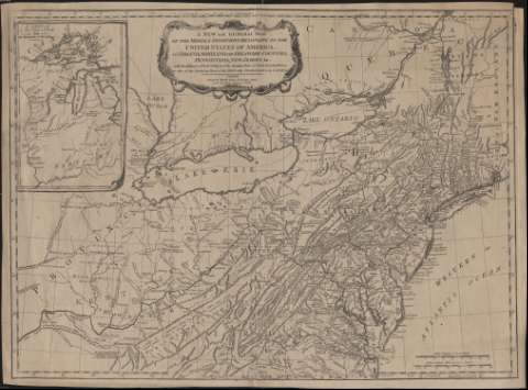
A New and General Map of the Middle Dominions Belonging to the United States of América : viz Virginia, Maryland,... (1788)
Maps, plans and nautical charts
A New and General Map of the Middle Dominions Belonging to the United States of América : viz Virginia, Maryland,... (1788)
 Disponible Holdings
 Section: Maps, plans and nautical charts
Uniform title: Estados Unidos. Mapas generales. 1788. 1:2.000.000
Title: A New and General Map of the Middle Dominions Belonging to the United States of América : viz Virginia, Maryland, the Delaware-Counties, Pennsylvania, New Jersey, etc. with the Addition of New York, and of the Greatest Part of New England, etc. as also of the Bordering of the British Possessions in Canadá
Material or type of resouce Area: Escala [ca. 1:2.000.000]. 130 british statute miles 69 1/2 to a degree [= 10,1 cm] ; proyec. cónica ( (O 85º25'-O 71º50'/N 46º45'-N 36º25')
Publication: London : Robert Sayer, 1788
Physical description: 1 mapa : grab. ; 49 x 67 cm
Content type: Imagen cartográfica
Media type: computadora
Carrier type: recurso en línea
Notes: Escala también expresada en 40 leguas de 20 al grado
Meridiano de origen: Londres. Red geográfica de 1º en 1º
Relieve por montes de perfil. Figura red hdrográfica
Abundante toponimia
Divisiones administrativas diferenciadas por líneas punteadas
Costas sombreadas
Título enmarcado en cartela orlada
Inserta: "A Sketch of the Upper Parts to shew the Rematinder of the Lakes"
Materia / lugar / evento: Mapas generales
Relaciones exteriores
Fronteras
Estados Unidos
Other authors: Sayer, Robert, 1725-1794
UDC: (73-11)
Type of publication:
Maps
Rights:
Préstamo:
Disponible
