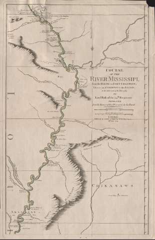
Course of the river Mississipi, from the Balise to Fort...


 Maps, plans and nautical charts
Course of the river Mississipi, from the Balise to Fort Chartres : taken on an expedition to the Illinois, in the... (1794)
Maps, plans and nautical charts
Course of the river Mississipi, from the Balise to Fort Chartres : taken on an expedition to the Illinois, in the... (1794)
 Disponible Holdings
 Section: Maps, plans and nautical charts
Title: Course of the river Mississipi, from the Balise to Fort Chartres : taken on an expedition to the Illinois, in the latter end of the year 1765 / by Lieut. [John] Ross of the 34th. Regiment ; improved from the Surveys of that river made by the French ; published by Laurie & Whittle
Material or type of resouce Area: Escala [ca. 1:895.000], 15 sea leagues [= 9,4 cm]
Publication: London : published by Laurie & Whittle, 1794
Physical description: 1 mapa en 2 h. : col. ; h. de 57 x 35 cm
Content type: Imagen cartográfica
Media type: computadora
Carrier type: recurso en línea
Notes: Presenta el curso del río a su paso por el Estado de Louisiana hasta su desembocadura
Escala gráfica de 50 millas británicas de 69 1/2 al grado [= 9 cm]. Longitud del meridiano de Nueva Orleans
Orientado con lis
Relieve de perfil y representado por normales
Materia / lugar / evento: Cuencas hidrográficas
Expediciones geográficas
Luisiana (Estados Unidos, Estado)
Mississippi (Río)
Other authors: Ross, John
Robert Laurie and James Whittle
UDC: 73:282.272.7
Type of publication:
Maps
Rights:
Préstamo:
Disponible
