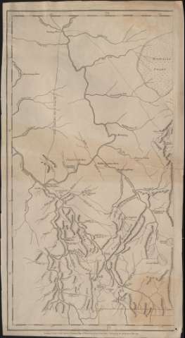
A Map of Pennsylvania : Exhibiting not only the Improved...


 Maps, plans and nautical charts
A Map of Pennsylvania : Exhibiting not only the Improved Parts of that Province, but also its Extensive Frontiers.. (1775)
Maps, plans and nautical charts
A Map of Pennsylvania : Exhibiting not only the Improved Parts of that Province, but also its Extensive Frontiers.. (1775)
 Disponible Holdings
 Section: Maps, plans and nautical charts
Uniform title: Pensilvania. Mapas generales. 1775. 1:370.000
Title: A Map of Pennsylvania : Exhibiting not only the Improved Parts of that Province, but also its Extensive Frontiers..
Material or type of resouce Area: Escala [ca. 1:370.000]. 30 english miles [= 13 cm] ( (O 79º46'-O 74º20'/N 41º48'-N 39º37')
Publication: London : Printed for Robt. Sayer & J. Bennett, 1775
Physical description: 1 mapa en 3 h. : grab. ; h. de 69 x 36 cm ó menos
Content type: Imagen cartográfica
Media type: computadora
Carrier type: recurso en línea
Notes: Bajo el título: "To the Honourable Thomas Penn and Richard Penn Esquires..."
Meridiano de origen: Londres
Relieve por montes de perfil y sombreado
Divisiones administrativas diferenciadas por líneas de color
Coloreado a la acuarela en rojo, verde y amarillo
Materia / lugar / evento: Mapas generales
Divisiones administrativas
Orografía
Pensilvania
Estados Unidos
Other authors: Robert Sayer and John Bennett (Firma)
UDC: (748)
Type of publication:
Maps
Rights:
Préstamo:
Disponible
