A New and Accurate Map of Virginia : Wherein most of the...


 Maps, plans and nautical charts
A New and Accurate Map of Virginia : Wherein most of the Counties are laid down from Actual Surveys with A Concise... (1770)
Maps, plans and nautical charts
A New and Accurate Map of Virginia : Wherein most of the Counties are laid down from Actual Surveys with A Concise... (1770)
 Disponible Holdings
 Section: Maps, plans and nautical charts
Uniform title: Virginia. Mapas generales. 1770. 1:460.000
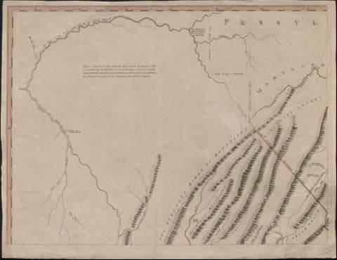
Title: A New and Accurate Map of Virginia : Wherein most of the Counties are laid down from Actual Surveys with A Concise Account of the Number of Inhabitants, the Trade, Soil, and Produce of that Province / by John Henry ; Engraved by Thomas Jeffreys Geographer to the King
Material or type of resouce Area: Escala [ca. 1:460.000]. 40 british statute miles [= 13,9 cm]
Publication: London : Thomas Jeffreys, 1770
Physical description: 1 mapa en 4 h. : grab., col. ; h. de 49 x 66 cm
Content type: Imagen cartográfica
Media type: computadora
Carrier type: recurso en línea
Notes: Escala expresada también en 40 millas geográficas de 60 al grado [= 16,1 cm]
Orientado con lis inscrita en rosa de 16 vientos
Meridiano de origen: Williamsbury
Relieve por montes de perfil
Divisiones administrativas diferenciadas por líneas de color
Título enmarcado en cartela decorada con motivos arquitectónicos sobre un paisaje con escena costumbrista
Nota explicativa sobre los habitantes, el trabajo, el sueldo y la producción
Materia / lugar / evento: Mapas generales
Demografía
Divisiones administrativas
Virginia
Estados Unidos
Other authors: Jefferys, Thomas, ca. 1710-1771
Henry, John
UDC: (755)
Type of publication:
Maps
Rights:
Préstamo:
Disponible
