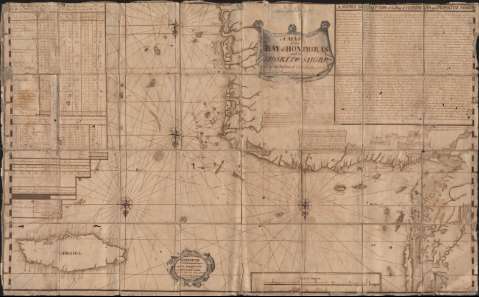
A Map of the Bay of Honduras and the Moskito Shore : with...


 Maps, plans and nautical charts
A Map of the Bay of Honduras and the Moskito Shore : with the Number of Inhabitants and the Commodities Exported... (1782)
Maps, plans and nautical charts
A Map of the Bay of Honduras and the Moskito Shore : with the Number of Inhabitants and the Commodities Exported... (1782)
 Disponible Holdings
 Section: Maps, plans and nautical charts
Uniform title: HONDURAS (Golfo). Cartas náuticas. 1:450000 (1782)
Title: A Map of the Bay of Honduras and the Moskito Shore : with the Number of Inhabitants and the Commodities Exported from... in one year / This map was drawn in 1782 by Colonel Robert Hodgson
Material or type of resouce Area: Scale [ca. 1:450.000]. 50 leagues [= 25,2 cm]
Publication: 1782
Physical description: 1 carta náutica : ms., montado sobre tela ; 72,6 x 116,5 cm
Content type: Imagen cartográfica
Media type: computadora
Carrier type: recurso en línea
Notes: Mención de responsabilidad ilegible
Orientado con 4 rosas de los vientos y lis con el N. al S. de la hoja. Nudo de rumbos. Márgenes graduados
Nota explicativa de la zona en la parte superior izquierda del mapa y nota de descripción en la parte derecha
Título en filacteria y referencias en cartela barroca
Batimetría por sondas, bajos y veriles. Toponimia costera. Ciudades más importantes representadas por edificación religiosa. Hidrografía
Materia / lugar / evento: Cartas náuticas
Comercio marítimo
Belice
Guatemala
Honduras
Genre / form: Manuscritos
Other authors: Hodgson, Robert P
UDC: 728.3 Honduras
Type of publication:
Maps
Rights:
Préstamo:
Disponible
