A New map of the whole Continent of America divided into...


 Maps, plans and nautical charts
A New map of the whole Continent of America divided into North and South and west Indies : wherein are exactly... (1794)
Maps, plans and nautical charts
A New map of the whole Continent of America divided into North and South and west Indies : wherein are exactly... (1794)
 Disponible Holdings
 Section: Maps, plans and nautical charts
Uniform title: AMERICA. Mapas generales. 1794 (1783). 1:1380000
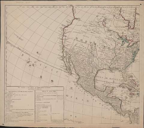
Title: A New map of the whole Continent of America divided into North and South and west Indies : wherein are exactly Described the United States of North America as well as the Several European possesions according to the Preliminaries of peace signed at Versailles Jan 20 1783 : Compiled from Mr. D'Anville's maps of that Continent, with the addition of the spanish Discoveries in 1775 to the north of California & corrected in the several parts belonging to Great Britain, from Original Material of Governor Pownall, MP
Material or type of resouce Area: [Ca. 1:13.800.000]
Publication: London : Laurie & Whittle, 1794
Physical description: 1 mapa en cuatro hojas ; 52 x 59 cm cada hoja
Content type: Imagen cartográfica
Media type: computadora
Carrier type: recurso en línea
Notes: Escala deducida de leguas comunes francesas de 25 al grado. Escalas expresadas además en millas geográficas de 60 al grado, leguas marinas inglesas y francesas de 20 al grado, leguas marinas españolas de 17 1/2 al grado, etc
Título enmarcado con grabado de paisaje tropical
Demarcación de límites en amarillo, rojo y verde
Recuadro con posesiones pertenecientes a cada reino o estado
Inserta mapa de las Bahías de Hudson y Baffin
Materia / lugar / evento: Mapas generales
Descubrimientos geográficos
América
Other authors: Robert Laurie and James Whittle
UDC: 912:341.241:325.45:910.4(7/8)"1794"
7/8
Type of publication:
Maps
Rights:
Préstamo:
Disponible
