Mapa General [de España]


 Maps, plans and nautical charts
Mapa General [de España] (1880)
- Valverde y Álvarez, Emilio, 1848-1894
Maps, plans and nautical charts
Mapa General [de España] (1880)
- Valverde y Álvarez, Emilio, 1848-1894
 Disponible Holdings
 Section: Maps, plans and nautical charts
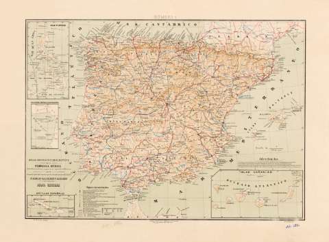
Title: Mapa General [de España] / E. Valverde, dibujo ; A. Soler, grabó
Author: Valverde y Álvarez, Emilio, 1848-1894
[Mapa general de España] All editions
Characteristics of the edition: 1880. 3.280.000. Español
Material or type of resouce Area: Escala 1:3.280.000
Publication: [Madrid] : Litoga. e Impta. de la Biblioteca Universal, [1880]
Physical description: 1 mapa : grab., col., montado sobre tela ; 31 x 44 cm en h. de 38 x 51 cm
Content type: Imagen cartográfica
Media type: computadora
Carrier type: recurso en línea
Notes: Título completado a partir del contenido del documento
Sobre el título: "Atlas Geográfico descriptivo de la Península Ibérica, Islas Baleares, Canarias y Posesiones Españolas de ultramar por el comandte. capn. de Infa. auxiliar que ha sido del Déposito de la Guerra D. Emilio Valverde y Álvarez". En el margen superior: "número 1"
Coordenadas referidas al meridiano de Madrid (O 6°--E 7°/N 43°--N 35°). Red geográfica de 1° en 1°
Relieve por sombreado
Tabla de signos convencionales para indicar capitales de distrito militar y provincia, capitales de provincia, capitales de distrito militar de Portugal que no son capitales de provincia, ciudades, villas, centros de batallones de reserva y de depósito, carreteras, capitales de provincia marítima de 1a., 2a. y 3a. clase, arzobispados y obispados, etc
Inserta: "Islas Filipinas". 1:20.000.000. 12 x 6,5 cm; "Posesiones españolas en el Golfo de Guinea". 1:12.000. 7 x 4,3 cm; "Antillas españolas". 1:25.200.000. 3,5 x 7,5 cm; "Islas Canarias"; 1:3.280.000. 7,5 x 14,5 cm
Materia / lugar / evento: Regiones militares
Divisiones administrativas
Colonias
1880
España
Portugal
Genre / form: Mapas generales
Mapas militares
UDC: 912:[355.3(-2/-5)]:325.45:(1-35)(460)(469)"1880"
(460)
(469)
Type of publication:
Maps
Rights:
Préstamo:
Disponible
