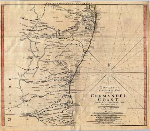
Bowles's new pocket map of the Cormandel Coast : from the...


 Maps, plans and nautical charts
Bowles's new pocket map of the Cormandel Coast : from the Sr. D'Anville Secretary to the Duke of Orleans (17--?)
Maps, plans and nautical charts
Bowles's new pocket map of the Cormandel Coast : from the Sr. D'Anville Secretary to the Duke of Orleans (17--?)
 Disponible Holdings
 Section: Maps, plans and nautical charts
Title: Bowles's new pocket map of the Cormandel Coast : from the Sr. D'Anville Secretary to the Duke of Orleans
Material or type of resouce Area: Escala [ca. 1:823.100]
Publication: London : printed for Carington Bowles, at N°69 in St. Pauls Church Yard, [17--?]
Physical description: 1 mapa en 2 h. : col. ; 95 x 56 cm en h. de 50 x 58 cm
Content type: Imagen cartográfica
Media type: computadora
Carrier type: recurso en línea
Notes: Carta arrumbada que comprende la costa este de la península india desde Navasapur hasta Nagappattinam
Destaca especialmente la red hidrográfica
Escalas gráficas de 20 leguas marinas de 20 en grado [= 13'5 cm] 20 leguas francesas, 25 "Coss" comunes, 25 "Coss" grandes, 10 leguas de Malabar y 60 millas estatutarias británicas. Graduado únicamente en latitud (N 17°15'--N 10°35'). Orientado con dos lises
Orografía de perfil
Reproducción digital
Materia / lugar / evento: Hidrografía
Genre / form: Documentos archivísticos
Mapas generales
Other authors: Bowles, Carrington, 1724-1793
España. Dirección de Hidrografía, productor. Expediciones a Indias
Museo Naval (Madrid). Archivo. Documentos gráficos, Mapas
Type of publication:
Maps
Rights:
Préstamo:
Disponible
