Chart of Bligh's Islands = Carta de las Yslas de Bligh :...


 Maps, plans and nautical charts
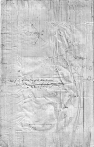
Chart of Bligh's Islands = Carta de las Yslas de Bligh : discovered by William Bligh in the Bounty's Launch
Maps, plans and nautical charts
Chart of Bligh's Islands = Carta de las Yslas de Bligh : discovered by William Bligh in the Bounty's Launch
 Disponible Holdings
 Section: Maps, plans and nautical charts
Uniform title: Chart of Bligh's Islands. 1789. Inglés. 1:1500000
Title: Chart of Bligh's Islands = Carta de las Yslas de Bligh : discovered by William Bligh in the Bounty's Launch
Material or type of resouce Area: Escala [ca. 1:1.500.000]
Publication: (1789)
Physical description: 1 mapa : ms. ; 33'9 x 43'6 cm
Content type: Imagen cartográfica
Media type: computadora
Carrier type: recurso en línea
Notes: carta de la parte más septentrional de las islas de Nueva Hébridas, con escala gráfica de 30 millas EN MN 54-D-23
Carta náutica de las islas de la Bondad, en la que se determina la calidad del fondo de las mismas, en base a las observaciones tomadas desde la lancha Bounty durante su derrota por el Océano Pacífico Sur; línea de derrotaésta, que esta presente en el documento
Escala gráfica en 60 millas marítimas
Orientado con nudo de 4 rumbos y media lis
Reproducción digital
Materia / lugar / evento: Expediciones geográficas
1789
Derroteros
Vanuatu
Genre / form: Manuscritos
Cartas náuticas
Documentos archivísticos
Other authors: España. Dirección de Hidrografía, productor. Expediciones a Indias
Museo Naval (Madrid). Archivo. Documentos gráficos, Mapas
Type of publication:
Maps
Rights:
Préstamo:
Disponible
