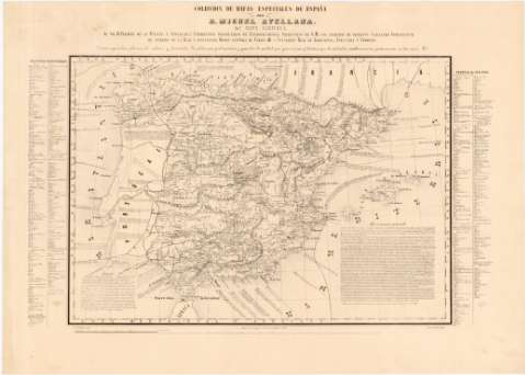
Mapa Agrícola [de España]


 Disponible Holdings
 Section: Maps, plans and nautical charts
Title: Mapa Agrícola [de España] / por Miguel Avellana ; M. Laborda grabó
Author: Avellana, Miguel
[Mapa Agrícola] All editions
Characteristics of the edition: 1859. 1:2.850.000. Español
Material or type of resouce Area: Escala [ca. 1:2.850.000]. 60 leguas legales [= 11,8 cm]
Publication: Madrid : Litoga. de J. Aragon, Urosas 10, 1859
Physical description: 1 mapa : grab., montado sobre tela ; 37 x 52 cm
Content type: Imagen cartográfica
Media type: computadora
Carrier type: recurso en línea
Series: (Colección de Mapas Especiales de España ; 10)
Notes: Dedicatoria: "Al Sr. D. Fermín de la Puente y Apecechea, Catedrático propietario de Jurisprudencia..., Consejero Real de Agricultura, Industria y Comercio"
Coordenadas referidas al meridiano de Madrid (O 7°20'--E 9°45'/N 44°00'--N 35°00'). Red geográfica de 1° en 1°
Relieve representado por curvas de configuración
Tabla de signos convencionales para indicar poblaciones con grandes zonas agrícolas y de otros productos, de ganado, escuelas de veterinaria y asociaciones de ganaderos y comisiones auxiliares.
Nota "Advertencia general" en la que da noticia de las fuentes empleadas para la construcción del mapa y una explicación de las características climáticas, suelos, cultivos y vegetación espontánea que se da en cada zona
En los márgenes consta una relación con los nombres de las plantas forestales y de cultivo agrupadas por zonas geográficas
Materia / lugar / evento: Agricultura
Ganadería
Vegetación
1859
Genre / form: Mapas temáticos
Other authors: Laborda, M
Litografía de J. Aragón (Madrid)
UDC: 912:63:338.43+581.9+636(460)"1859"
(460)
Type of publication:
 Maps
Maps
Rights:
Préstamo:
Disponible
