Map of the Kingdoms of Spain and Portugal, including...


 Maps, plans and nautical charts
Map of the Kingdoms of Spain and Portugal, including Algarve : Describing The Post Roads their Stations and... (May 1823)
- Faden, William, 1749-1836
Maps, plans and nautical charts
Map of the Kingdoms of Spain and Portugal, including Algarve : Describing The Post Roads their Stations and... (May 1823)
- Faden, William, 1749-1836
 Disponible Holdings
 Section: Maps, plans and nautical charts
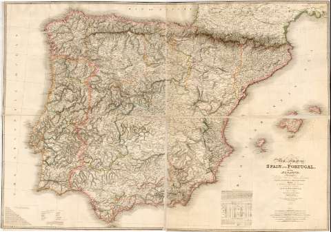
Title: Map of the Kingdoms of Spain and Portugal, including Algarve : Describing The Post Roads their Stations and Distances, chains of mountains and military passes, Likewise The Places of the Principal Actions, during the late Campaigns in the Peninsula / By W. Faden Geographer to His Majesty
Author: Faden, William, 1749-1836
[Map of the Kingdoms of Spain and Portugal, including Algarve] All editions
Characteristics of the edition: 1823. 1:730.000. Inglés
Edición: Additions to 1829
Material or type of resouce Area: Escala [ca. 1:730.000]. 20 leguas españolas de 17 1/2 al grado [= 17,4 cm]
Publication: London : Published by Jas. Wyld (successor to W.Faden) Geographer to His Majesty & to His Royal Highness the Duke of York. N° 5, Charing Cross, May 1823
Physical description: 1 mapa : grab., col., montado sobre tela ; 123 x 177 cm
Content type: Imagen cartográfica
Media type: computadora
Carrier type: recurso en línea
Notes: Escala también expresada en otras unidades. Coordenadas referidas al meridiano de Greenwich (O 11°15'/E 5°15'/N 43°47'-N 35°44'). Red geográfica de 1° en 1°
Relieve representado por normales
Tabla para indicar en leguas españolas las distancias entre las principales ciudades de España
Incluye una relación de términos geográficos en castellano e inglés
Notas describiendo las principales características geográficas de España y Portugal. Incluye también sendas tablas donde se indica la división administrativa de ambos países, información poblacional de cada provincia, su territorio expresado en leguas de 17 1/2 al grado y las capitales
Divisiones administrativas y de países diferenciadas por líneas de color
Genre / form: Mapas generales
Other authors: Wyld, James, 1790-1836
UDC: 912:(1-3/-4)(46)"1829"
(460)
(469)
Type of publication:
Maps
Rights:
Préstamo:
Disponible
