A new Map of Spain and Portugal : exhibiting the Chains...


 Maps, plans and nautical charts
A new Map of Spain and Portugal : exhibiting the Chains of Mountains with their Passes, the Principal & Cross Road,... (1810)
- Nantiat, Jasper
Maps, plans and nautical charts
A new Map of Spain and Portugal : exhibiting the Chains of Mountains with their Passes, the Principal & Cross Road,... (1810)
- Nantiat, Jasper
 Disponible Holdings
 Section: Maps, plans and nautical charts
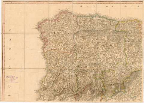
Title: A new Map of Spain and Portugal : exhibiting the Chains of Mountains with their Passes, the Principal & Cross Road, with other detatails requisite for the Intelligence of Military Operations / Compiled by Jasper Nantiat
Author: Nantiat, Jasper
[A new Map of Spain and Portugal] All editions
Characteristics of the edition: 1810. 1:870.000. Inglés
Material or type of resouce Area: Escala [ca. 1:870.000]. 60 millas geográficas o náuticas de 60 en grado [= 12,8 cm]
Publication: London : Published by W. Faden, Geographer to His Majesty & to His Royal Highness the Prince of Wales, Charing Cross, 1810
Physical description: 1 mapa en 4 hoja : col., montado sobre tela ; 112 x 156 cm, en hoja de 158 x 80 cm
Content type: Imagen cartográfica
Media type: computadora
Carrier type: recurso en línea
Notes: Escala también expresada en otras unidades. Coordenadas referidas al meridiano de Londres (O 11°20'--E 5°20'/N 43°55'--N 35°25'). Recuadro geográfico de 1° en 1°
Orografía representada por normales
Señala la división administrativa entre regiones y países
Tabla de signos convencionales para indicar núcleos de población de diferente categoría, caminos y fortificaciones, y relación de términos geográficos en castellano e inglés
Tabla de distancias entre las principales ciudades de España
Nota indicativa de los datos que se han tenido en cuenta para la realización de este mapa, señalando además alguno de los principales pasos fronterizos
Realizado en sesenta y cuatro cuarterones y montado en cuatro piezas
Genre / form: Mapas generales
Other authors: Faden, William, 1749-1836
UDC: (460)
(469)
Type of publication:
Maps
Rights:
Préstamo:
Disponible
